|
Log - 3/6 - 5/9/2004 Turks & Caicos Islands to the Bahamas In this log Alan describes cruising through the Turks and Caicos Islands and the Bahamas. This page includes the following sections:
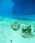
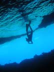
Puerto Rico to the Turks (Mar 6, 2004 - 18°01´N, 67°10´W) After too much time in Puerto Rico, a barely acceptable weather window appeared. At dawn Squiz set sail northwest from Boqueron to the Turks and Caicos Islands. High wind and waves made the first day rather miserable and splashy; but, as predicted, the weather mellowed and the sailing improved on Sunday. While approaching uninhabited Big Sand Cay (in the southern Turks) Katherine spotted a humpback whale. Near the Turks the depth of the Atlantic Ocean abruptly changes from thousands of feet deep to less than a hundred feet deep, making for striking transitions in water color. In our anchorage the clear, sandy shallows were an indescribably beautiful blue-turquoise. Soon after anchoring we jumped in the water to check the anchor and move our passage-constrained bodies; I could see the anchor 100' away. At last, the clear water I have been fantasizing about for the last three years has materialized. Peak Experience (Mar 8 , 2004 - 21°12´N, 71°15´W) Excellent visibility in the water around Big Sand Cay made for pleasant snorkeling with David and Frank (new friends that sail nice Catana catamarans). The coral was substandard, nonetheless I was entertained while finning around the shallows by the distant alien moaning of humpback whales, two sea turtles, a few barracuda, and a lobster. After squizzing a 4' nurse shark, we returned to the dinghy and motored over to check out another spot. Here the whale song was louder; I surfaced to tell David (who was manning the dinghy as we drifted with the current); he animatedly described whales surfacing a few hundred feet away. I swam in the indicated direction for a few minutes and dove down. In the distant blue I noticed two slowly undulating, whitish, creatures. My first thought was, "Weird. Could that be two 7' long white dolphins?" Swimming closer, details materialized. An adult humpback whale – with whitish pectoral flippers – and her baby leisurely swam by. Close behind swam an even larger third whale. Zounds! Frank and I returned to the dinghy and blathered excitedly while watching the retreating cetaceans. Then we arced the dinghy around 100 yards to the side of the trio's path. We slipped into the water again. Amazingly, the whales allowed David and I to get close. I submerged and the mom and calf passed about 60' away form me. I finned toward the following male humpback; when I was 30' from the leviathan he turned on a complex multi-frequency scan that was very heavy in the base frequencies. I think I was being analyzed. I was left with the feeling that his sonic probe determined my position, speed, velocity, species, size, heart rate, bone density, and what I had for lunch. Or maybe it was just laughing at my dorkiness. Anyway, it was better than THX and definitely a highlight of my time on Earth. Caicos (Mar 11, 2004 - 21°29´N, 71°32´W) Excessive wind and waves in marginally protected anchorages, slightly frustrated our enjoyment of the Turks and Caicos. For a time we put up with uncomfortable anchorages because the visibility & sea life were very good. It was a pleasure to consistently see snapper, grouper, lobster, and conch. Snorkeling was occasionally enlivened as a shark or a large ray wandered by. One day four parrotfish were queued up waiting for a tiny yellow wrasse to clean the parrotfish's teeth. Tired of rolly anchorages in the Caicos, we pressed onward to the southeast Bahamas. At Mayaguana Island we checked into the country and hunkered down for a couple days of rough weather. After the high winds abated, we headed toward Samana – an uninhabited island described as having good sea life and a protected anchorage (if you can make it through a narrow, unmarked cut in the reef). Southeast Bahamas (Mar 19 , 2004 - 22°22´N, 72°59´W) We approached the reef-strewn entrance into the Samana with extreme trepidation. We made a couple passes to squiz the anchorage entrance, conditions were not good -- the following seas were breaking all around the reef cut; waves and clouds reduced below-water visibility. During our third approach to the cut the clouds thinned, so we gambled and made a high-stakes, scary entrance into the anchorage in Samana. During our entry my instruments didn't see any depths less than ten feet; but when the depth sounder stopped reading for a several seconds, I almost needed new underwear. Although we made it through the reef successfully, this was probably the riskiest/stupidest thing I have done in three years of cruising. After anchoring, our folly was rewarded as we removed the ocean's two dumbest lobsters from the gene pool. Katherine spied them both crawling out of their cave (maybe they thought it was nighttime due to the overcast skies). I speared the first one & was de-tailing it, when the other one came out and watched as I prepared to nab it. Dinner was hot & sour soup with lobster tail chunks – yum, yum. After two pleasant days in Samana the forecast predicted another week of nasty weather with very high seas – this would make the Samana reef passage totally untenable. With no viable nearby alternatives, we elected for a long sail northwest to Rum Cay in the central Bahamas. The island was not very interesting, but luckily some friends were also anchored here and socialization made waiting for weather more enjoyable. Eventually, the forecast called for a week of decent weather, so we will motorsailed 25 miles to Conception Island. This lovely, uninhabited island has many of reefs scattered nearby and my cruising guide asserts that some of the best snorkeling in the Bahamas can be found here. Wrongo! I snorkeled all around Conception Island and the reefs are very mediocre. Another recent victim of mankind's assault on nature. . But, one can find the occasional grouper. In one cave under a coral head in 20 ft of water, was a nice sized grouper (29" long, about 7-10 lbs). I speared it, unfortunately it wiggled off the spear and retreated under the coral head to a tight spot to die. But, after ten minutes of persistent searching and poking I was able to retrieve the glorious beast, before any sharks arrived. About ten minutes after I finished filleting the fish (on board s/v Squiz) three sharks did arrive to recycle on the grouper viscera. Katherine was initially timid about eating a grouper that was so large (due to the ciguatera poisoning that is occasionally a problem with large reef fish in the Bahamas). Happily, we survived; and the blessed grouper provided three excellent meals (this was our FIRST grouper since leaving Mexico). Great Exuma (Apr 6, 2004 - 23°31´N, 75°44´W) Moving on to Great Exuma Island, Squiz anchored in a few places near Georgetown - the only significant town in the central Bahamas. Here we caught up on boat maintenance, did laundry, and enjoyed resting in a peaceful/protected anchorage. At sixty cents per gallon for drinking water, filling the water tank was an expensive proposition.
Exumas (Apr 22, 2004 - 23°54´N, 76°17´W) Leaving behind the crowds of Georgetown, we headed “up” the Exumas – a chain of closely spaced small islands in the central Bahamas. Near our anchorage off Cave Cay, we were blessed with a four-serving grouper. The vast, shallow Bahama banks lie to the west of the Exumas. The 2' - 20' depths reflect a lovely green light and noticeably color the underside of clouds and the wings of seagulls flying above the banks. This western side of the Exumas is often smooth, as the islands protect it from the from waves coming in from the Atlantic. North of Cave Cay the water was deep enough to sail over the banks. This was some of the most beautiful and pleasant sailing of my life.
A 60-mile stretch of the central Exumas around Wardrick Wells has been designated a preserve/park. In this park the sea life is decent. Large lobsters are a common site - knowing they are protected, the lobsters love to laugh at the hungry-eyed snorkelers swimming by. At Wardrick Wells my reliable Yamaha outboard engine for my shuttlecraft/dinghy died. In spite of extensive mechanical resuscitation (by myself and a mechanically talented friend) the outboard refused to be resurrected. So, tomorrow we headed to Nassau to try to find a new carburetor (or a Yamaha shaman). Northwest Bahamas (May 3, 2004 - 25°04´N, 77°19´W) During the last six months of cruising we had only stopped in a marina for one night. Pulling into a marina in Nassau was quite an event. Particularly amazing was the water spigot - just turn the handle and incredible amounts of water are available for washing the boat, showering, etc. - what decadence. After trudging around Nassau I located a new carburetor for the dinghy outboard, installed it, and briefly checked that the outboard would now start. The next day we sailed happily to the Devil's Island in the Berry island group. On May 6th the winds were perfect to knock out the long 77 NM (89 mile) passage across the shallow Bahama banks to Gun Cay. Since the first two hours were in relatively deep water, we set the alarm clock for 5 AM and set sail under a large moon. In order to go through the shallows during daylight hours, we kept s/v Squiz moving quickly. During a great broad reach we averaged 6.5 knots using one reef in the main and the jib. But that glorious big moon caused big tidal variations. Although the vague guide book declared that we should have a least 8' depths at low tide, the water gradually became more and more shallow. It is quite unnerving to sail a 5' 10" deep boat (with 13 tons of inertia) in 7' deep water. When the depth sounder indicated a depth of 6' 6", we quickly and chaotically dropped the sails. Then we drifted downwind at 3.2 knots with the engine in idle. Twice the depth sounder flashed 5.6' and we lightly touched the sandy bottom. Eventually the depth increased, I have never been so happy to see the boat in a mere 7' of water. After two nights in a rocking anchorage west of Gun Cay, we headed across the gulf stream to Fort Lauderdale, Florida. Where our oceanic adventure wound down and other possibilities await. |
Other Related Pages: Life is either a daring adventure or nothing. To keep our faces toward change and behave like free spirits in the presence of fate is strength undefeatable.
The longer I live, the more I read, the more patiently I think, and the more anxiously I inquire, the less I seem to know....Do justly, Love mercy. Walk humbly. This is enough." |
|